Beyond perception: seismic risk in eastern Canada rivals western provinces
October 12, 2023
By
Haley Nagasaki
Natural Resources Canada scientists Tiegan Hobbs and Alison Bird share findings on nationwide seismic risk and mitigative technologies deploying over the coming months
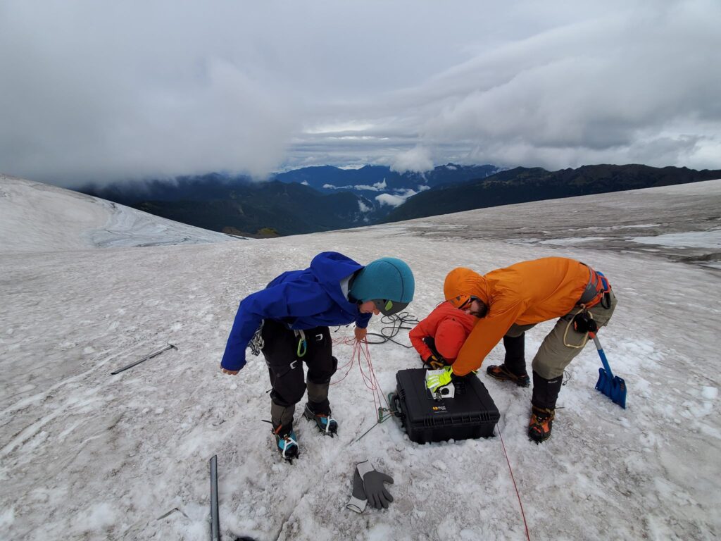 Geological Survey of Canada field work. Photo: Tiegan Hobbs, PhD, MSCE
 In 2011, within a couple of months apart, two serious earthquakes shook Tohoku, Japan and Christchurch, New Zealand and proved bigger than previously thought possible in those regions. In retrospect, the Pacific islands’ preparedness fell short as they had perhaps been planning for smaller events – a similar phenomenon Canada may also be facing.
For Vancouver-born-and-raised seismic risk scientist at Natural Resources Canada (NRCan) and UBC adjunct professor Tiegan Hobbs, it seems as though the more she learns about earthquakes, “the more questions we have as a community.” Growing up in Vancouver in the 90s, Hobbs experienced “the early stages of figuring that the Cascadia megathrust was a threat to the city of Vancouver and to southwestern B.C.” This includes Vancouver Island and the province’s capital Victoria, a location that global researchers often model after Christchurch, N.Z. in terms of seismic risk and potential outcome.
Alison Bird, earthquake seismologist with NRCan and Vancouver Island resident, in 2020, began a new role as liaison and outreach officer for the earthquake early warning program. Bird and her team have helped usher NRCan’s process forward, “developing an earthquake early monitoring system for the higher risk regions of Canada: western B.C., eastern Ontario and southern Quebec,” she says.
While the western seismic threat has been recognized for decades, the lesser-known risk in the east (Quebec and Ontario) is almost equal to that in B.C., due to the greater number of buildings with more vulnerable construction style of buildings and higher population in the eastern provinces; unbeknownst to many.
Assessing threats posed by these sleeping giants will help better prepare both emergency managers and the greater public, while new technology providing up to tens of seconds of warning will help shift towards a proactive approach to earthquake preparedness, replacing fear driven reactions with rapid, lifesaving decision making.
Geological factors informing seismic risk
Western Canada is the most active and researched seismic region in the country. This is largely due to the Cascadia subduction zone, “the region from Northern Vancouver Island down to Northern California, where the Juan de Fuca tectonic plate is subducting, or sliding beneath the North American plate,” says Hobbs.
Subduction zones are important because “you can’t generate a magnitude nine earthquake anywhere else; you need so much surface area to have that much energy release,” she says. These are megathrust events, where an earthquake occurs between two plates. Tension earthquakes can also occur “when the subducting plate dives into the earth, getting pulled in by the earth, and that tension in the plate as it’s being pulled can cause earthquakes as well,” Hobbs explains.
While the subduction zones are offshore, the tension quakes might occur right below city centres, like Vancouver, Victoria, or Seattle, in addition to the shallow, crustal earthquakes that are a daily occurrence in western Canada.
“Sometimes they’re on fault lines, like the Queen Charlotte Fault towards Alaska, which is a northern sister to the San Andreas Fault.” Sometimes crustal events don’t occur on plate boundaries, like the 2011 Christchurch event and the 1946 Vancouver Island earthquake occurred on a fault within the North American Plate.
Recent field work in the Coast Mountains. Photo: Tiegan Hobbs
Public perception: beyond Western Canada
“In a lot of ways, eastern Canada has just as much risk as western or possibly even a little bit more,” says Hobbs.
The region along the St. Lawrence River, including the St. Lawrence lowlands, Ottawa, and the border between Quebec and Ontario has experienced historical earthquakes that caused damage and loss of life.
Despite the public perception that only western is Canada at risk, a comparison of provinces and territories shows that British Columbia has the highest risk, followed by Quebec. Ontario and Yukon also show significant risk in terms of total or proportional impact.
“Yukon has quite high seismic hazard, but it has fewer people, fewer buildings, whereas Ontario has a lower probability of shaking but much more exposure – a lot more people a lot more buildings.” In terms of the third riskiest province and territory, “it can be a toss-up between Ontario and Yukon depending on how you look at it,” says Hobbs.
Introducing secondary hazards
Big megathrust earthquake events can displace a lot of water, especially on the west coast. “We haven’t been tested very much on our tsunami preparedness in B.C.,” says Hobbs. Tsunami preparedness is essential, even for those who are not directly living on the west coast of Vancouver Island.
Liquefaction, where soil behaves temporarily as liquid, can cause roads to buckle, buildings to tilt, and other damages to infrastructure. After the 2011 Christchurch event, approximately 50 per cent of the road network needed replacing as a result, cites Hobbs. Landslides triggered by earthquakes can also pose a great threat to safety and infrastructure. Aftershocks, which can last for months, years, or even decades, are another concern; they are the smaller events following the main earthquake.
Additionally, the rupture of gas lines and electrical damage can lead to fire outbreaks, making fire following a significant secondary hazard. The historical example of the 1906 earthquake in San Francisco demonstrates the destructive potential of fires that follow an earthquake as being more damaging than the quake itself.
Mitigative technology
After years of preparation, NRCan’s earthquake early warning (EEW) system will be ready to launch in spring 2024. That is, a network of sensors to alert the surrounding regions designed to provide critical seconds of warning to citizens. “We have most of the sensors installed in B.C. and more than half of them installed in eastern Canada,” says Bird.
This same effective USGS software used in the Washington, Oregon, and California will be employed in Canada, facilitating transnational data sharing for better reaction time on both sides of the border.
The specialized sensors will send data to two data centres, where the earthquake is rapidly evaluated, then alert messages are sent directly to critical infrastructure operators where automatic responses will be employed, such as the opening of firehall doors and the stopping of trains. Additionally, alerts will be sent to the public through the National Public Alert System, or Alert Ready already in use for severe weather and Amber Alerts.
“These automated technologies are phenomenal,” says Bird. “Last year there was an earthquake in Tohoku, Japan, and the trains were stopped. The tracks were badly damaged, and if the trains (carrying hundreds of people) had continued, they would have derailed.”
While the EEW system does not preclude the need for building code standards, it can be immensely beneficial in providing seconds to tens-of-seconds of warning before the strong shaking occurs.
“Some buildings have already been retrofitted to be made safer but, regardless of the building you’re in, usually the best thing to do is drop, cover, and hold on. This is not an evacuation alert, this is a ‘Drop, Cover, Hold on’ alert,” affirms Bird.
In Part 2 of this article, we will explore practical steps to emergency preparedness for earthquakes and secondary hazards nationwide.
Print this page